
Portal:World
The World Portal


The world is the totality of entities, the whole of reality, or everything that exists. The nature of the world has been conceptualized differently in different fields. Some conceptions see the world as unique while others talk of a "plurality of worlds". Some treat the world as one simple object while others analyze the world as a complex made up of parts.
In scientific cosmology, the world or universe is commonly defined as "[t]he totality of all space and time; all that is, has been, and will be". Theories of modality talk of possible worlds as complete and consistent ways how things could have been. Phenomenology, starting from the horizon of co-given objects present in the periphery of every experience, defines the world as the biggest horizon or the "horizon of all horizons". In philosophy of mind, the world is contrasted with the mind as that which is represented by the mind. Theology conceptualizes the world in relation to God, for example, as God's creation, as identical to God or as the two being interdependent. In religions, there is a tendency to downgrade the material or sensory world in favor of a spiritual world to be sought through religious practice. A comprehensive representation of the world and our place in it, as is found in religions, is known as a worldview. Cosmogony is the field that studies the origin or creation of the world while eschatology refers to the science or doctrine of the last things or of the end of the world.
In various contexts, the term "world" takes a more restricted meaning associated, for example, with the Earth and all life on it, with humanity as a whole or with an international or intercontinental scope. In this sense, world history refers to the history of humanity as a whole and world politics is the discipline of political science studying issues that transcend nations and continents. Other examples include terms such as "world religion", "world language", "world government", "world war", "world population", "world economy", or "world championship". (Full article...)
Selected articles -
-

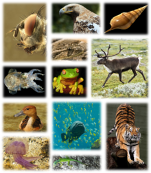
Examples of the multicellular biodiversity of the Earth.
Global biodiversity is the measure of biodiversity on planet Earth and is defined as the total variability of life forms. More than 99 percent of all species that ever lived on Earth are estimated to be extinct. Estimates on the number of Earth's current species range from 2 million to 1 trillion, but most estimates are around 11 million species or fewer. About 1.74 million species were databased as of 2018, and over 80 percent have not yet been described. The total amount of DNA base pairs on Earth, as a possible approximation of global biodiversity, is estimated at 5.0 x 1037, and weighs 50 billion tonnes. In comparison, the total mass of the biosphere has been estimated to be as much as 4 TtC (trillion tons of carbon).
In other related studies, around 1.9 million extant species are believed to have been described currently, but some scientists believe 20% are synonyms, reducing the total valid described species to 1.5 million. In 2013, a study published in Science estimated there to be 5 ± 3 million extant species on Earth although that is disputed. Another study, published in 2011 by PLoS Biology, estimated there to be 8.7 million ± 1.3 million eukaryotic species on Earth. Some 250,000 valid fossil species have been described, but this is believed to be a small proportion of all species that have ever lived. (Full article...) -
Proto-globalization or early modern globalization is a period of the history of globalization roughly spanning the years between 1600 and 1800, following the period of archaic globalization. First introduced by historians A. G. Hopkins and Christopher Bayly, the term describes the phase of increasing trade links and cultural exchange that characterized the period immediately preceding the advent of so-called "modern globalization" in the 19th century.
Proto-globalization distinguished itself from modern globalization on the basis of expansionism, the method of managing global trade, and the level of information exchange. The period is marked by the shift of hegemony to Western Europe, the rise of larger-scale conflicts between powerful nations such as the Thirty Years' War, and demand for commodities, most particularly slaves. The triangular trade made it possible for Europe to take advantage of resources within the western hemisphere. The transfer of plant and animal crops and epidemic diseases associated with Alfred Crosby's concept of the Columbian exchange also played a central role in this process. Proto-globalization trade and communications involved a vast group including European, Middle Eastern, Indian, Southeast Asian, and Chinese merchants, particularly in the Indian Ocean region. (Full article...) -

King Sargon II of the Neo-Assyrian Empire (right) had the full titulature of Great King, Mighty King, King of the Universe, King of Assyria, King of Babylon, King of Sumer and Akkad. Stele housed at the British Museum, London.
King of the Universe (Sumerian: lugal ki-sár-ra or lugal kiš-ki, Akkadian: šarru kiššat māti, šar-kiššati or šar kiššatim), also interpreted as King of Everything, King of the Totality, King of All or King of the World, was a title of great prestige claiming world domination used by powerful monarchs in ancient Mesopotamia. The title is sometimes applied to God in the Abrahamic tradition.
The etymology of the title derives from the ancient Sumerian city of Kish (Sumerian: kiš, Akkadian: kiššatu), the original meaning being King of Kish. Although the equation of šar kiššatim as literally meaning "King of the Universe" was made during the Akkadian period, the title of "King of Kish" is older and was already seen as particularly prestigious, as the city of Kish was seen as having primacy over all other Mesopotamian cities. In Sumerian legend, Kish was the location where the kingship was lowered to from heaven after the legendary Flood. (Full article...) -
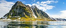
The Alps (/ælps/) are one of the highest and most extensive mountain ranges in Europe, stretching approximately 1,200 km (750 mi) across eight Alpine countries (from west to east): Monaco, France, Switzerland, Italy, Liechtenstein, Germany, Austria and Slovenia.
The Alpine arch extends from Nice on the western Mediterranean to Trieste on the Adriatic and Vienna at the beginning of the Pannonian Basin. The mountains were formed over tens of millions of years as the African and Eurasian tectonic plates collided. Extreme shortening caused by the event resulted in marine sedimentary rocks rising by thrusting and folding into high mountain peaks such as Mont Blanc and the Matterhorn. (Full article...) -

Global urbanization map showing the percentage of urbanization and the biggest global population centres per country in 2018, based on UN estimates.
Urbanization (or urbanisation in British English) is the population shift from rural to urban areas, the corresponding decrease in the proportion of people living in rural areas, and the ways in which societies adapt to this change. It can also mean population growth in urban areas instead of rural ones. It is predominantly the process by which towns and cities are formed and become larger as more people begin living and working in central areas.
Although the two concepts are sometimes used interchangeably, urbanization should be distinguished from urban growth. Urbanization refers to the proportion of the total national population living in areas classified as urban, whereas urban growth strictly refers to the absolute number of people living in those areas. It is predicted that by 2050 about 64% of the developing world and 86% of the developed world will be urbanized. This is predicted to generate artificial scarcities of land, lack of drinking water, playgrounds and so on for most urban dwellers. The predicted urban population growth is equivalent to approximately 3 billion urbanites by 2050, much of which will occur in Africa and Asia. Notably, the United Nations has also recently projected that nearly all global population growth from 2017 to 2030 will be by cities, with about 1.1 billion new urbanites over the next 10 years. In the long term, urbanization is expected to significantly impact the quality of life in negative ways. (Full article...) -
The Space Age is a period encompassing the activities related to the space race, space exploration, space technology, and the cultural developments influenced by these events, beginning with the launch of Sputnik 1 on October 4, 1957, and continuing to the present.
This period is characterized by changes in emphasis on particular areas of space exploration and applications. Initially, the United States and the Soviet Union invested unprecedented amounts of resources in breaking records and being first to meet milestones in crewed and uncrewed exploration. The United States established the National Aeronautics and Space Administration (NASA) and the USSR established the Kosmicheskaya programma SSSR to meet these goals. This period of competition gave way to cooperation between those nations and emphasis on scientific research and commercial applications of space-based technology. (Full article...) -

Old Moore's Almanack is an astrological almanac which has been published in Britain since 1697.
An almanac (also spelled almanack and almanach) is a regularly published listing of a set of current information about one or multiple subjects. It includes information like weather forecasts, farmers' planting dates, tide tables, and other tabular data often arranged according to the calendar. Celestial figures and various statistics are found in almanacs, such as the rising and setting times of the Sun and Moon, dates of eclipses, hours of high and low tides, and religious festivals. The set of events noted in an almanac may be tailored for a specific group of readers, such as farmers, sailors, or astronomers. (Full article...)


General images -
-
 Yggdrasil, an attempt to reconstruct the Norse world tree which connects the heavens, the world, and the underworld. (from World)
 -
 A view of Earth with its global ocean and cloud cover, which dominate Earth's surface and hydrosphere; at Earth's polar regions, its hydrosphere forms larger areas of ice cover. (from Earth)
 -

-
 Ajloun Castle, Jordan
 -

-
 Geologic map of North America, color-coded by age. From most recent to oldest, age is indicated by yellow, green, blue, and red. The reds and pinks indicate rock from the Archean.
 -

-
 An artist's impression of the Archean, the eon after Earth's formation, featuring round stromatolites, which are early oxygen-producing forms of life from billions of years ago. After the Late Heavy Bombardment, Earth's crust had cooled, its water-rich barren surface is marked by continents and volcanoes, with the Moon still orbiting Earth half as far as it is today, appearing 2.8 times larger and producing strong tides. (from Earth)
 -
 Chennakesava Temple, Belur, India
 -
 Shanghai. China urbanized rapidly in the 21st century.
 -
 Map of peopling of the world (Southern Dispersal paradigm), in thousands of years ago.
 -

-
 Earth's western hemisphere showing topography relative to Earth's center instead of to mean sea level, as in common topographic maps (from Earth)
 -
 Great Pyramids of Giza, Egypt
 -
 A composite image of Earth, with its different types of surface discernible: Earth's surface dominating Ocean (blue), Africa with lush (green) to dry (brown) land and Earth's polar ice in the form of Antarctic sea ice (grey) covering the Antarctic or Southern Ocean and the Antarctic ice sheet (white) covering Antarctica. (from Earth)
 -
 View of Earth from the Moon by the Lunar Reconnaissance Orbiter (from Earth)
 -
 Pale orange dot, an artist's impression of Early Earth, featuring its tinted orange methane-rich early atmosphere (from Earth)
 -
 Great Mosque of Kairouan, Tunisia, founded 670 CE
 -
 Satellite time lapse imagery of Earth's rotation showing axis tilt (from Earth)
 -
 Japanese depiction of a Portuguese carrack. European maritime innovations led to proto-globalization.
 -
 A reconstruction of human history based on fossil data. (from History of Earth)
 -
 Chloroplasts in the cells of a moss (from History of Earth)
 -

-

-
 A 2012 artistic impression of the early Solar System's protoplanetary disk from which Earth and other Solar System bodies were formed (from Earth)
 -

-
 An animation of the changing density of productive vegetation on land (low in brown; heavy in dark green) and phytoplankton at the ocean surface (low in purple; high in yellow) (from Earth)
 -

-

-

-
 Persepolis, Achaemenid Empire, 6th century BCE
 -
 A reconstruction of Pannotia (550 Ma). (from History of Earth)
 -
 Machu Picchu, Inca Empire, Peru
 -
 Earth's land use for human agriculture in 2019 (from Earth)
 -

-
 A pillar at Göbekli Tepe
 -
 Graph showing range of estimated partial pressure of atmospheric oxygen through geologic time (from History of Earth)
 -
 Image of the physical world, captured by the Hubble Space Telescope (from World)
 -
Artist's impression of Earth during the later Archean, the largely cooled planetary crust and water-rich barren surface, marked by volcanoes and continents, features already round microbialites. The Moon, still orbiting Earth much closer than today and still dominating Earth's sky, produced strong tides. (from History of Earth)
-
 Taj Mahal, Mughal Empire, India
 -
 Earth's night-side upper atmosphere appearing from the bottom as bands of afterglow illuminating the troposphere in orange with silhouettes of clouds, and the stratosphere in white and blue. Next the mesosphere (pink area) extends to the orange and faintly green line of the lowest airglow, at about one hundred kilometers at the edge of space and the lower edge of the thermosphere (invisible). Continuing with green and red bands of aurorae stretching over several hundred kilometers. (from Earth)
 -
 Florence, birthplace of the Italian Renaissance
 -
 Last Moon landing: Apollo 17 (1972)
 -

-
 An artist's rendering of a protoplanetary disk (from History of Earth)
 -
 Vitruvian Man by Leonardo da Vinci epitomizes the advances in art and science seen during the Renaissance. (from History of Earth)
 -
 Standing Buddha from Gandhara, 2nd century CE
 -
 Obelisk of Axum, Ethiopia
 -
 Artist's conception of Devonian flora (from History of Earth)
 -
 Cross-section through a liposome (from History of Earth)
 -

-
 A Benin Bronze head from Nigeria
 -
 A computer-generated image mapping the prevalence of artificial satellites and space debris around Earth in geosynchronous and low Earth orbit (from Earth)
 -
 An artist's impression of ice age Earth at glacial maximum. (from History of Earth)
 -
 Artist's impression of a Hadean landscape with the relatively newly formed Moon still looming closely over Earth and both bodies sustaining strong volcanism. (from History of Earth)
 -
 Notre-Dame de Paris, France
 -
 Dinosaurs were the dominant terrestrial vertebrates throughout most of the Mesozoic (from History of Earth)
 -

-
 Empires of the world in 1898
 -

-
 A banded iron formation from the 3.15 Ga Moodies Group, Barberton Greenstone Belt, South Africa. Red layers represent the times when oxygen was available; gray layers were formed in anoxic circumstances. (from History of Earth)
 -
 Change in average surface air temperature and drivers for that change. Human activity has caused increased temperatures, with natural forces adding some variability. (from Earth)
 -
 The Pantheon, originally a Roman temple, now a Catholic church
 -
 Earth's history with time-spans of the eons to scale (from History of Earth)
 -

-
 A schematic view of Earth's magnetosphere with solar wind flowing from left to right (from Earth)
 -

-

-
 Battle during 1281 Mongol invasion of Japan
 -
 Lithified stromatolites on the shores of Lake Thetis, Western Australia. Archean stromatolites are the first direct fossil traces of life on Earth. (from History of Earth)
 -
 A composite image of artificial light emissions at night on a map of Earth (from Earth)
 -
 Artist's impression of the enormous collision that probably formed the Moon (from History of Earth)
 -
 Earth's axial tilt causing different angles of seasonal illumination at different orbital positions around the Sun (from Earth)
 -
The pale orange dot, an artist's impression of the early Earth which might have appeared orange through its hazy methane rich prebiotic second atmosphere. Earth's atmosphere at this stage was somewhat comparable to today's atmosphere of Titan. (from History of Earth)
-
 Angkor Wat temple complex, Cambodia, early 12th century
 -
 "Lucy", the first Australopithecus afarensis skeleton found. Lucy was only 1.06 m (3 ft 6 in) tall.
 -
 Trilobites first appeared during the Cambrian period and were among the most widespread and diverse groups of Paleozoic organisms. (from History of Earth)
 -
 Pangaea was a supercontinent that existed from about 300 to 180 Ma. The outlines of the modern continents and other landmasses are indicated on this map. (from History of Earth)
 -
 Artist's conception of Hadean Eon Earth, when it was much hotter and inhospitable to all forms of life. (from History of Earth)
 -

-
 Tiktaalik, a fish with limb-like fins and a predecessor of tetrapods. Reconstruction from fossils about 375 million years old. (from History of Earth)
 -
 Olmec colossal head, now at the Museo de Antropología de Xalapa
 -
 Artist's rendition of an oxinated fully-frozen Snowball Earth with no remaining liquid surface water. (from History of Earth)
 -
 A map of heat flow from Earth's interior to the surface of Earth's crust, mostly along the oceanic ridges (from Earth)
 -
 A view of Earth with different layers of its atmosphere visible: the troposphere with its clouds casting shadows, a band of stratospheric blue sky at the horizon, and a line of green airglow of the lower thermosphere around an altitude of 100 km, at the edge of space (from Earth)
 -
 The replicator in virtually all known life is deoxyribonucleic acid. DNA is far more complex than the original replicator and its replication systems are highly elaborate. (from History of Earth)
 -
 A 580 million year old fossil of Spriggina floundensi, an animal from the Ediacaran period. Such life forms could have been ancestors to the many new forms that originated in the Cambrian Explosion. (from History of Earth)
 -
 Tracy Caldwell Dyson, a NASA astronaut, observing Earth from the Cupola module at the International Space Station on 11 September 2010 (from Earth)
 -
 Fall of the Berlin Wall, 1989
 -

-
 First airplane, the Wright Flyer, flew on 17 December 1903.
 -
 Ming dynasty section, Great Wall of China


.jpg)
.jpeg)


.jpg)


.svg)
.jpg)

Megacities of the world -
.jpg)
Buenos Aires (/ˌbweɪnəs ˈɛəriːz/ or /-ˈaɪrɪs/; Spanish pronunciation: [ˈbwenos ˈajɾes] ⓘ), officially the Autonomous City of Buenos Aires, is the capital and primate city of Argentina. The city is located on the western shore of the Río de la Plata, on South America's southeastern coast. "Buenos aires" is Spanish for "fair winds" or "good airs". Buenos Aires is classified as an Alpha global city, according to the Globalization and World Cities Research Network (GaWC) 2020 ranking.
The city of Buenos Aires is neither part of Buenos Aires Province nor the Province's capital; rather, it is an autonomous district. In 1880, after decades of political infighting, Buenos Aires was federalized and removed from Buenos Aires Province. The city limits were enlarged to include the towns of Belgrano and Flores; both are now neighborhoods of the city. The 1994 constitutional amendment granted the city autonomy, hence its formal name of Autonomous City of Buenos Aires. Its citizens first elected a Chief of Government in 1996; previously, the Mayor was directly appointed by the President of Argentina. (Full article...)Did you know -

- ... that the economy of Tolkien's Middle-earth has been described as a mix of feudalism and capitalism, with one scholar even suggesting it had communist elements?
- ... that the vast majority of fiction, including science fiction, takes place on Earth?
- ... that the founder of the Guide to the Free World, helping people leave Russia after its invasion of Ukraine, said she was told: "It's good that you get out of Russia, but a pity that you won't be shot"?
- ... that Tin Srbić was the first Croatian to win a gold medal at the World Artistic Gymnastics Championships?
- ... that the joint National War Fund was created during World War II so that American citizens would not get annoyed by multiple donation requests for service members' support and overseas relief?
- ... that the chicken turtle is one of the shortest-lived turtle species in the world?
- ... that Mack Trucks adopted the Bulldog as its corporate logo after World War I British soldiers nicknamed the Mack AC the "Bulldog", a reference to the model's tenacity and stub nose?
- ... that the Baratal limestone in Russia may be one of the oldest atolls in the world?
Countries of the world -

Mexico, officially the United Mexican States, is a country in the southern portion of North America. It covers 1,972,550 km2 (761,610 sq mi), making it the world's 13th-largest country by area; with a population of almost 130 million, it is the 10th-most-populous country and the most populous Spanish-speaking country. Mexico is organized as a federal constitutional republic comprising 31 states and Mexico City, its capital. It shares land borders with the United States to the north, with Guatemala and Belize to the southeast; as well as maritime borders with the Pacific Ocean to the west, the Caribbean Sea to the southeast, and the Gulf of Mexico to the east.

The Seven Wonders of Wales (Welsh: Saith Rhyfeddod Cymru) is a traditional list of notable landmarks in north Wales, commemorated in an anonymously written rhyme:
The rhyme is usually supposed to have been written sometime in the late 18th or early 19th century by an English visitor to North Wales. The specific number of wonders may have varied over the years: the antiquary Daines Barrington, in a letter written in 1770, refers to Llangollen Bridge as one of the "five wonders of Wales, though like the seven wonders of Dauphiny, they turn out to be no wonders at all out of the Principality". (Full article...)Related portals
Protected areas of the world -
-
The northernmost tip of Prins Karls Forland in Forlandet National Park
Svalbard is an Arctic wilderness archipelago comprising the northernmost part of Norway. There are twenty-nine protected natural areas, consisting of seven national parks, six nature reserves, fifteen bird sanctuaries and one geotope protected area. In addition, human traces dating from before 1946 are automatically protected. The protected areas make up 39,800 square kilometers (15,400 sq mi) or 65% of the land area, and 78,000 square kilometers (30,000 sq mi) or 86.5% of the territorial waters. The largest protected areas are Nordaust-Svalbard Nature Reserve and Søraust-Svalbard Nature Reserve, which cover most of the areas east of the main island of Spitsbergen, including the islands of Nordaustlandet, Edgeøya, Barentsøya, Kong Karls Land and Kvitøya. Six of the national parks are located on Spitsbergen. Ten of the bird sanctuaries and the Moffen Nature Reserve are located within national parks. Five of the bird sanctuaries are Ramsar sites and fourteen of the bird sanctuaries are islands. Svalbard is on Norway's tentative list for nomination as a UNESCO World Heritage Site.
The supreme responsibility for conservation lies with the Norwegian Ministry of the Environment, which has delegated the management to the Governor of Svalbard and the Norwegian Directorate for Nature Management. The foundation for conservation was established in the Svalbard Treaty of 1920, and has been further specified in the Svalbard Environmental Act of 2001. The first round of protection took force on 1 July 1973, when most of the current protected areas came into effect. This included the two large nature reserves and three of the national parks. Moffen Nature Reserve was established in 1983, followed by four national parks, three nature reserves and one geotope protection area between 2002 and 2005. (Full article...) -
As of present, there are around 400 protected areas in Pakistan that are recognized by IUCN. The total protected land area represents 13% of Pakistan's landmass as of 2020, The Government of Pakistan plans to increase it to at least 15% by 2023. As a signatory of the UN Convention on Biological Diversity, Pakistan is committed to expanding its protected areas to encompass 17% of its total territory by the year 2030. This ambitious goal aims to ensure the long-term conservation of nature, safeguard vital ecosystem services, and preserve the cultural values associated with these protected areas. (Full article...)
-
Protected areas of Tamil Nadu cover an area of 3,305 km2 (1,276 sq mi), constituting 2.54% of the geographic area and 15% of the 22,643 km2 (8,743 sq mi) recorded forest area of the state of Tamil Nadu in South India. It ranks 14th among all the states and union territories of India in terms of total protected area.
Protected areas in South India were created from private hunting grounds of the erstwhile Maharajas of the princely states. Mudumalai National Park was established in 1940 and was the first modern wildlife sanctuary in South India. The protected areas are administered by the Ministry of Environment and Forests of Government of India and the Tamil Nadu Forest Department. (Full article...) -
Forests in the state of Himachal Pradesh (northern India) currently cover an area of nearly 37,939 square kilometres (14,648 sq mi), which is about 68.16% of the total land area of the state. The forests were once considered to be the main source of income of the state and most of the original forests were clear felled. The emphasis has shifted, however, from exploitation to conservation. The state government aims to increase forest cover to 50% of the total land area. There have been various projects, including the establishment of protected areas such as National Parks, designed to preserve and expand the forests. (Full article...)
-
A list of protected areas of Oman:
- Al Wusta Wildlife Reserve
- Ra's Al Hadd Turtle Reserve
- Ad Dimaniyat Islands Reserve
- Al Saleel National Park (As Salil Natural Park)
- Jabal Samhan Nature Reserve
- Al Jabal Al Akhdar Scenic Reserve
- Western Hajer Stars Lights Reserve
- Arabian Oryx Sanctuary
- Al Rustaq Wildlife Reserve
- Al Wusta Wetland Reserve
- Jabal Qahwan Nature Reserve
- Al Sareen Nature Reserve
- Ras al Shajar Nature Reserve
- Al Khuwuair Nature Reserve
- Khawrs of the Salalah Coast Reserve
-
Protected areas of Eswatini include any geographical area protected for a specific use inside the landlocked country of Eswatini, in southern Africa.
Within Eswatini there is a mix of national, private and community-owned protected areas. They include national parks, nature reserves, wildlife sanctuaries and game reserves. (Full article...) -
This is a list of protected areas of Sierra Leone, including national parks, game reserves, conservation areas, wetlands, and those that are listed as proposed protected areas in the UN Environment Programme World Conservation Monitoring Centre (UNEP WCM) database. (Full article...)
-
Greece is characterized by an extremely fragmented, rugged landscape hosting a great diversity of ecosystems and an outstanding biodiversity. Almost 5% of its extensive coastline consists of ecologically sensitive wetlands. Two thirds of the total population live no further than 2 km from the coast and most of the important urban centers are coastal, while almost all of the tourist infrastructure is divided among islands and the coastal mainland. (Full article...)
-
Protected areas of the Caribbean are significant in a region of particular ecological vulnerability, including the impact of climate change and the impact of tourism.
The University of the West Indies' "Caribbean Protected Areas Gateway" supports informational resources for the 16 Caribbean member states of the Organisation of African, Caribbean and Pacific States. It forms the regional component of the ACP's Biodiversity and Protected Areas Management program, building on the World Database on Protected Areas. (Full article...) -
The National Parks of Argentina make up a network of 35 national parks in Argentina. The parks cover a very varied set of terrains and biotopes, from Baritú National Park on the northern border with Bolivia to Tierra del Fuego National Park in the far south of the continent. The Administración de Parques Nacionales (National Parks Administration) is the agency that preserves and manages these national parks along with Natural monuments and National Reserves within the country.
The headquarters of the National Parks Service are in downtown Buenos Aires, on Santa Fe Avenue. A library and information centre are open to the public. The administration also covers the national monuments, such as the Jaramillo Petrified Forest, and natural and educational reserves. (Full article...) -
This is a list of protected areas of Romania.
About 5.18% of the area of Romania has a protected status (12,360 km2), including the Danube Delta, which makes half of these areas (2.43% of Romania's area). (Full article...) -
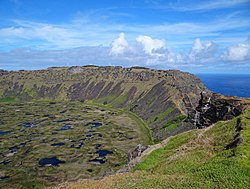
Rano Kau, Parque National Rapa Nui, Easter Island
The protected areas of Chile are areas that have natural beauty or significant historical value protected by the government of Chile. These protected areas cover over 140,000 km2 (54,054 sq mi), which is 19% of the territory of Chile. The National System of Protected Wild Areas (SNASPE by its Spanish acronym) is regulated by law #18,362 passed in 1984, and administered by the National Forest Corporation (CONAF).
There are three types of territories: (Full article...) -

Cranes at Sevan National Park
This is a list of protected areas in Armenia that are categorized as follows: 4 national parks, 3 state reserves, 27 state sanctuaries and 5 botanical gardens. (Full article...) -
Illinois has a variety of protected areas, including over 123 state-protected areas, dozens of federally protected areas, hundreds of county-level and municipal park areas. Illinois also contains sites designated as internationally important protected areas. These multiple levels of protection contribute to a statewide network of numerous recreation opportunities and conservation schemes, sometimes in a small area. For example, DeKalb County contains a 1,000-acre (4.0 km2) forest preserve system and a 1,500-acre (6.1 km2) state park (Shabbona Lake State Park); within DeKalb County, the DeKalb Park District in the City of DeKalb has a 700-acre (2.8 km2) park system. (Full article...)
-
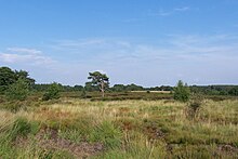
Heathland at the Hoge Kempen National Park
There are numerous protected areas in Belgium with a wide variety of types, protection levels and sizes. The below list gives an overview of the most important protected areas. (Full article...)


Selected world maps
-
 The world map by Gerardus Mercator (1569), the first map in the well-known Mercator projection
 -
 Index map from the International Map of the World (1:1,000,000 scale)
 -
 Only a few of the largest large igneous provinces appear (coloured dark purple) on this geological map, which depicts crustal geologic provinces as seen in seismic refraction data
 -
 The Goode homolosine projection is a pseudocylindrical, equal-area, composite map projection used for world maps.
 -
 A plate tectonics map with volcano locations indicated with red circles
 -
 Time zones of the world
 -
 Mollweide projection of the world
 -
 United Nations Human Development Index map by country (2016)
 -
 1516 map of the world by Martin Waldseemüller


World records
- List of Olympic records in athletics
- List of world records in athletics
- List of junior world records in athletics
- List of world records in masters athletics
- List of world youth bests in athletics
- List of IPC world records in athletics
- List of world records in canoeing
- List of world records in chess
- List of cycling records
- List of world records in track cycling
- List of world records in finswimming
- List of world records in juggling
- List of world records in rowing
- List of world records in speed skating
- List of world records in swimming
- List of IPC world records in swimming
- List of world records in Olympic weightlifting
Topics

Continents of Earth | ||||||||
|---|---|---|---|---|---|---|---|---|
| ||||||||
| ||||||||
| ||||||||


| Cenozoic Era (present–66.0 Ma) |
| ||||||||||||
|---|---|---|---|---|---|---|---|---|---|---|---|---|---|
| Mesozoic Era (66.0–252 Ma) |
| ||||||||||||
| Paleozoic Era (252–539 Ma) |
| ||||||||||||
| Proterozoic Eon (539 Ma–2.5 Ga) |
| ||||||||||||
| Archean Eon (2.5–4 Ga) | |||||||||||||
| Hadean Eon (4–4.6 Ga) | |||||||||||||
ka = kiloannum (thousands years ago); Ma = megaannum (millions years ago); Ga = gigaannum (billions years ago). See also: Geologic time scale • | |||||||||||||
| Locations | ||
|---|---|---|
| Related | ||

| |||||||||||||||||||
| |||||||||||||||||||
| |||||||||||||||||||

Economic classification of countries | |||||
|---|---|---|---|---|---|
| Three-World Model | |||||
| Gross domestic product (GDP) |
| ||||
| Gross national income (GNI) | |||||
| Wages | |||||
| Wealth | |||||
| Other national accounts | |||||
| Human development | |||||
| Digital divide | |||||
| Net international investment position (NIIP) | |||||
| Technological |
| ||||
|---|---|---|---|---|---|
| Sociological | |||||
| Ecological |
| ||||
| Biological |
| ||||
| Astronomical | |||||
| Eschatological |
| ||||
| Others |
| ||||
| Fictional | |||||
| Organizations | |||||
Categories

Wikimedia
The following Wikimedia Foundation sister projects provide more on this subject:
-
 Commons
Free media repository -
 Wikibooks
Free textbooks and manuals -
 Wikidata
Free knowledge base -
 Wikinews
Free-content news -
 Wikiquote
Collection of quotations -
 Wikisource
Free-content library -
 Wikispecies
Directory of species -
 Wikiversity
Free learning tools -
 Wikivoyage
Free travel guide -
 Wiktionary
Dictionary and thesaurus


